Old US 31 in Northern Indiana |
|
I leaned forward in my chair, wondering when US 31 had ever been just two lanes in Indiana. All of my trips down US 31 to that time more than 20 years ago had been on the dull four-lane divided highway to Indianapolis. But there it was, a two-lane US 31 on an episode of The Fugitive, shot in the 1960s. I didn't know that most of US 31's original two-lane route in northern Indiana still existed. I also didn't know that the road had a long and important history before Richard Kimble stepped onto it on TV. But during the years I drove back and forth to college along US 31, I sometimes noticed road signs marked "Old US 31." I told myself I ought to explore them one day. I tried once near Rochester, and I promptly got lost. I was daunted. But even though I stuck to the well-marked roads for many years after that, my curiosity never abated. US 31 and I go way back because I grew up four blocks from it on South Bend's
south side. I used to ride my bike those four blocks to a little grocery when my
family ran out of milk.
The excerpt at left from a 1925 Rand McNally map shows all three designations along this stretch, which is highlighted in green. State Road 1 is marked by a circled 1, the Dixie Highway is marked by the number 25 in a dark square, and the Michigan Road is marked by the number 26 in a dark square. Then in 1927, the federal highway system came into being. US 31 shields appeared along the highway to reflect its new number, and the old names fell into disuse. I don't know just when, but it was probably in the 1960s and 1970s that US 31 was widened to four divided lanes and rerouted to bypass several towns. I'm sure the road was a welcome relief for travelers. But I grew to dislike the four-lane US 31 for being so boring to drive, and I tried to avoid it. I discovered the network of state highways, which usually added a little time to my trip but were a prettier and more engaging drive. Still, sometimes I ended up on US 31, where I was still curious about the original route. Then I discovered that old routes are often labeled on online maps. And then I found some old state maps and learned about the old Automobile Blue Books of the early 20th century and their turn-by-turn directions along the old routes. It was pretty easy to determine the route.
I was telling my old friend Brian, with whom I grew up in South Bend, about wanting to explore US 31's original route in northern Indiana someday. He enthusiastically recalled that trips to visit family in southern Indiana as a small child always began on the old two-lane US 31. He remembered that somewhere along the way it merged into the newly built four-lane. The more we talked, the more we knew we had to schedule a road trip as soon as we could. We managed to make our trip on September 15, 2007, a crisp and sunny early-autumn day.
To follow our tour, use the navigation links below. The easiest way to follow along is to click the Next button at the bottom right of each page. |
|
|
Created 13 January 2008. |
|
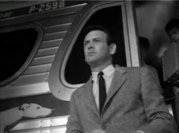 A man
in a gray suit stepped off a silver bus into the mist and night along a narrow
Indiana highway. He looked this way and that before quickly stepping away,
revealing a US 31 shield on the road behind him.
A man
in a gray suit stepped off a silver bus into the mist and night along a narrow
Indiana highway. He looked this way and that before quickly stepping away,
revealing a US 31 shield on the road behind him. 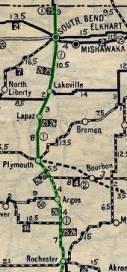 This
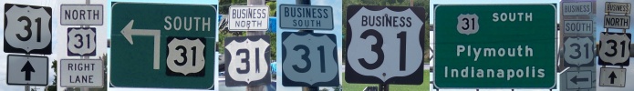
road has had other names. In the 1920s, Indiana created a state highway system
and gave this road the number 1.
This
road has had other names. In the 1920s, Indiana created a state highway system
and gave this road the number 1.
 Today there's serious talk of upgrading the entire route to freeway standards as
part of Governor Mitch Daniels'
Today there's serious talk of upgrading the entire route to freeway standards as
part of Governor Mitch Daniels'