State Road 37 from Indianapolis to Bloomington |
|||||||
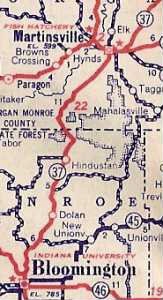
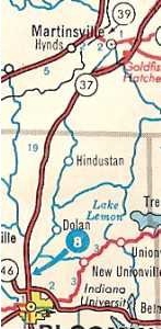
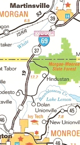
In mid-April of 2007 I was driving home on State Road 37 after visiting an old friend in Bloomington. It had been years since I'd traveled that road. Just south of Martinsville, I saw what looked like a strip of abandoned cement road, weeds growing through the cracks, on the edge of some farmer's field. I stopped to look, and saw that on the other side of a creek, where a bridge had been removed, lay more of that road, still drivable. I found my way to that road segment and followed it; it ended shortly to the south at State Road 37 again. It smelled like a segment of an old alignment to me! At home I logged onto Windows Live Local, my favorite satellite map site, and traced the highway. Not only did I find that little abandoned section, but I saw that the road was rich with segments of not one, but two old alignments of State Road 37. I began planning a road trip. Bloomington, like all other important Indiana cities, would want direct, good quality routes to the state's capital to conduct business and government. I have scans of state highway maps from 1917 and 1923. The road doesn't appear on the 1917 map, but that doesn't mean it wasn't there; it could have existed as a series of county roads that the state later assumed. State Road 37's original path appears on the 1923 map. The road, then mostly gravel and called State Road 22, wound through the southern Indiana hills. So the state has provided a direct route between Indianapolis and Bloomington for at least 84 years. 84 years ago roads had to flow with the terrain, winding, rising, falling. As technology improved, road builders became able to cut through the earth. As Hoosiers increasingly relied on motor transport, the original narrow, winding roads became insufficient. So Indiana improved its important roads, straightening them, making them bypass small towns, and often widening them to make them safer and allow speedier passage. Today, State Road 37 is almost Interstate quality — straight, smooth, and speedy. Notice how State Road 37’s path changed twice between Martinsville and Bloomington, as these three map excerpts show.
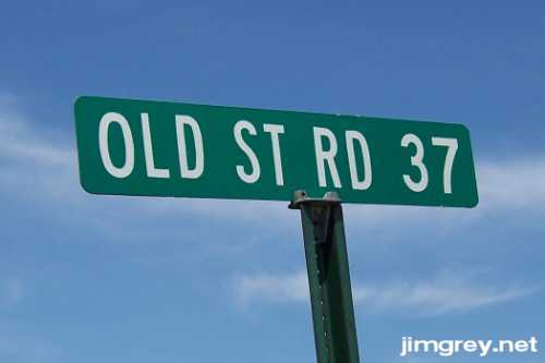
First, the road was straightened, smoothed, and moved to bypass Martinsville, Hindustan, and Dolan. Next, it was moved to bypass Bloomington. Somewhere in there it was expanded to four wide lanes with big shoulders. State Road 37 has become a superhighway. In the years to come, it will be upgraded to Interstate standards and given its new name, I-69, which the 2005 map predicts. Did you notice that the old road still runs through Martinsville, Hindustan, and Dolan? The 1970 map shows it clearly; the 2005 map not so much. But it's still there. When you drive down current State Road 37, you have to look carefully for the signs or you'll miss them. But they're there, and they say, "Old St Rd 37."
On Sunday, 13 May 2007, I drove as much of the original alignments of State Road 37 between Indianapolis and Bloomington that I could find. These pages document the trip. To read about each segment in order from north to south, click Indianapolis and then click Next on each page that follows. Or click on the segment that interests you. |
|||||||
Created 24 May 2007. |
|||||||